

New 3D City Model on the Map Portal
Jena Brings Urban Planning to Life Digitally
How does a new building affect its surroundings? Which buildings define a neighborhood? And what does Jena actually look like from a bird’s-eye view? Answers to these and many other questions are now available through the new 3D city model on the City of Jena’s map portal.
With this expansion, the city is consistently advancing its digital map portal. Residents can now explore the city in three dimensions and gain a much better sense of the city’s layout than before. The integration of the 3D city model adds a spatial representation to the previously two-dimensional map portal. This makes it possible to visualize urban structures, terrain features, and changes in the built environment more clearly and understand them better.
The digital model depicts the city area, including its terrain, bridges, and buildings, in their actual locations and forms. The buildings are shown with their characteristic roof shapes, such as gable, hipped, or shed roofs. The data foundation for the 3D city model has existed since the 2010s and has been continuously updated ever since. New constructions, building demolitions, and structural changes have thus been incorporated into the database on an ongoing basis. With the new solution, the previously standalone application is now being technically replaced and, at the same time, significantly expanded in terms of functionality.
“With its integration into the map portal, the 3D city model becomes a central component of the city’s digital geoinformation. Residents will have much easier access to spatial information and will be able to better understand and grasp the connections,” said Dorothea Prell, Smart City Coordinator and Overall Project Manager for the Jena Smart City Project.
New Features for Citizens
Through the map portal, users can virtually explore the city area and search specifically for locations and coordinates. The previous standalone application is thus not only technically replaced but also significantly enhanced in terms of functionality. The new features include, among others:
· simulation of shadows and lighting at various times of day,
· sun exposure analyses,
· measurements of heights, distances, and areas,
· drawing tools for creating custom 3D objects,
· exporting map views and objects.
Existing two-dimensional information from the map portal can also be displayed in the 3D view. This brings together various types of spatial information in a single, centralized application.
Especially for construction projects or changes to public spaces, the three-dimensional representation creates greater transparency. Citizens can get an early sense of how planned measures will fit into their surroundings and what effects they might have, for example, on sightlines or shading. This not only makes it easier to understand complex plans but also supports existing public participation processes by making planned changes more vivid and comprehensible to citizens.
Plans Made More Visual and Understandable
The 3D city model supports urban and land-use planning within the administration, the visualization of construction projects, and analyses of sightlines, shading, and solar potential. In addition, the dataset can serve as a basis for specialized applications in areas such as climate adaptation, heavy rain and flood prevention, or noise abatement.
For citizens, the model provides easier access to complex spatial information. Construction projects and changes to public spaces can be presented more clearly than in traditional two-dimensional plans. This increases the transparency of planning processes and can also support public participation procedures. Property owners can also use the model to better assess, for example, building heights, roof areas, elevation differences, or the amount of sunlight a property receives.
Developed jointly within the Smart City Network
The development of the new features for the 3D city model and its integration into the map portal were carried out as part of the City of Jena’s Smart City project. The application was developed in collaboration with the Smart Cities pilot projects in Detmold, Frankfurt am Main, and Wolfsburg. By sharing knowledge, experiences, and technical developments, synergies were leveraged to create a modern solution that benefits all participating cities. This collaboration demonstrates how innovative digital offerings can be developed more quickly through cooperation and create direct added value for urban society.
Access to the 3D City Model
The 3D city model can be accessed directly in the City of Jena’s map portal via the “Themes” menu and then via the map theme “3D City Model.” The previous web address remains active and redirects to the map portal.
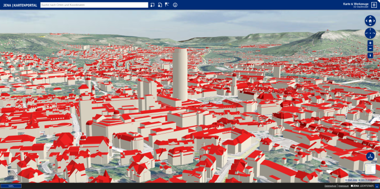
Das neue 3D-Stadtmodell im Kartenportal der Stadt Jena ermöglicht eine räumliche Ansicht des Stadtgebiets. Gebäude, Gelände und markante Bauwerke wie der JenTower lassen sich aus unterschiedlichen Perspektiven betrachten und analysieren.
© Stadt Jena